This is the homepage for various projects in measuring time-varying deformations with (mostly) longbase strainmeters and tiltmeters, primarily in southern California. The instruments are called ‘‘longbase’’ sensors because they produce high-quality data by measuring over distances of hundreds of meters at the surface of the Earth. Another type of strainmeter is that installed in deep boreholes; these measure over baselines of 0.1 meters or less. Support for the longbase strainmeters and tiltmeters is provided by the US Geological Survey, the Plate Boundary Observatory program (UNAVCO/NSF), the Southern California Earthquake Center, and the National Science Foundation.
If you wish to know more about these instruments, we have written a (very) detailed review describing how they work and some of the results we have obtained from them. This is about a 4.5 Mb PDF file, with lots of color plots, and is written for our fellow scientists, not for the layman.
This magnitude 7.2 event has been followed by postseismic strain changes (for detailed plots), some of which are probably caused by afterslip on the fault that ruptured, and other which suggest triggered slip on other faults.
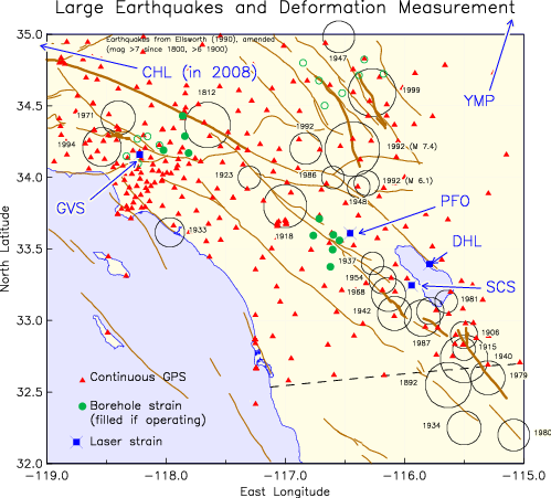
We are involved in operating sensors of this type at six different sites, four of which are shown on the first map, which also plots the location of continuous GPS sites installed before and during the PBO, and of borehole strainmeters operated by the US Geological Survey and the PBO.
|
• |
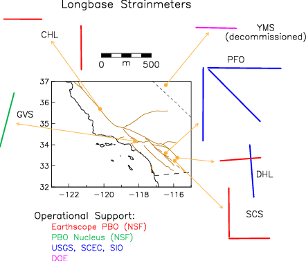
The Cecil and Ida Green Piñon Flat Observatory, (PFO), is where we have operated three longbase strainmeters, two longbase tiltmeters, and many related sensors over the past 35 years, between the active San Jacinto and San Andreas faults. |
||
|
• |
Durmid Hill, (DHL), is located very close to the southeast end of the San Andreas fault, and is where we operate two longbase instruments for tectonic studies: since 1994, a below-grade strainmeter (524 m), and since June 2005, a second surface instrument (405 m, DHM/DHL2), at right angles to it. The second system is one of five built as part of the Plate Boundary Observatory (PBO) project. Earlier a portable laser strainmeter (303 m) was deployed at different azimuths to study the (unantipated) local amplification of the earth-tide strain. Concerns over the possible initiation of a moderate earthquake in this area have routinely made the timely recordings of much interest recent data plot. |
||
|
• |
Glendale: Verdugo Canyon (GVS) is the site of a single-component longbase strainmeter, completed in 2002, north of downtown Los Angeles. Operations of this instrument are now supported by the PBO, as part of its "Nucleus" network. |
||
|
• |
Salton City (SCS), is an orthogonal pair of instruments, built as part of the PBO project, just south of Salton City, California, on the west side of the Salton Sea, directly across the sea from DHL. This instrument began operation in October 2006. |
||
|
• |
Cholame (CHL) is a site on the Vogel Ranch, south of Highway 46, near Cholame, California, which is near the supposed initiation point for the 1857 Fort Tejon earthquake, and is over a zone of unexplained non-volcanic tremor. In September 2008 we completed the 1.5-year-long fabrication of two orthogonal instruments. Initial records show that this area (immediately southeast of the 2006 Parkfield earthquake rupture) is undergoing substantial areal compression. |
||
|
• |
Yucca Mountain (YMS), is a single-compent instrument in a tunnel at Yucca Mountain in Nevada, a location being considered as a possible site for storage of radioactive waste. The strainmeter installation and operation is part of the Yucca Mountain Site Characterization Project This instrument operated between fall 2002 and March 2007, when access to the tunnel was ended because of budget cuts. |
Via the
HPWREN wireless research network,
which provides high-quality Internet access to the remote
strainmeter sites, and the Anza Project’s
ROADNet/Waveform Explorer program, which handles
real-time data, we are able both to keep a close watch on
the recordings (critical to rapid response to events, and to
data quality), and to make available plots of recent 1-Hz
data from all systems in near-real-time.
Making use of the
ROADNet/Waveform Explorer
website, the near real-time strainmeter recordings are
available, (say) for the PFO longbase strainmeters,
by requesting Channel 3 : Station
PFO4 for the NS strain, PFO5
for EW strain, and PFO6 for NW-SW
strain. Similarly for the other sites, enter CHL1, CHL2,
DHL1, DHL2, GVS1, SCS1, SCS2. (Series can be plotted in
parallel using the pipe symbol: e.g., CHL1|CHL2.)
Note that all these channels show uncorrected strain, which should not be used for research purposes.
All data from the PBO-supported instruments (GVS1, DHL2, SCS1, SCS2, CHL1, and CHL2) as well as that from the earlier installations (PFO4, PFO5, PFO6, and DHL1) are available at the PBO strain data archive at the NCEDC; for questions about the file formats, see the PBO documentation.
Longer-term data from the PFO and DHL strainmeters are available from when we installed our new datalogger/telemetry setup at each site. We make available files of "Level 2" data (fully processed) in PBO XML format here for DHL and here for PFO.
Data from the presently mothballed YMS strainmeter are available at the Technical Data Archive of the Harry Reid Center, University of Nevada (scroll down to Task ORD-FY04-008).
For older strainmeter data from GVS, PFO, or DHL, or other data from these facilities, please contact fwyatt at-sign ucsd dotsign edu.
We have a suite of programs available for working with strainmeter data; essentially, the ones we use ourselves, which we call PIASD (Programs for the Interactive Analysis of Strainmeter Data). They are well-documented, and should port to any Unix or Linux system.
We have also applied some of the lessons learned in strainmeter measurements to improving the quality of GPS measurements, in two ways:
|
• |
We have developed a design for a deeply-anchored geodetic monument which has been adopted as the standard for several networks of continuous GPS stations, most notably the SCIGN network in southern California. |
||
|
• |
As part of the SCIGN project we also designed an adaptor mount for GPS antennas (the so-called D3 antenna adaptor, which is intended to allow an antenna to be easily removed and precisely replaced reproducibly. This link includes plans and descriptions of the adaptor, and instructions for using it. Adaptors may be purchased from SCIGN; contact John McRaney (mcraney@usc.edu) for more information. Also see the description of the radome developed by the SCIGN/USGS group; this adaptor is designed to work with this dome. |
We are developing a page discussing different designs for geodetic monuments; additional links are always welcome.
The Black Forest Observatory in Germany is another location with strainmeters and tiltmeters (shorter-base, in an abandoned mine).
The Plate Boundary Observatory is the project installing GPS and strainmeters along the boundary between the Pacific and North American plates.