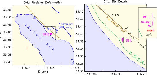
DHL is in the
region of strike-slip faults in southern California: indeed,
next to the most active fault, the San Andreas. The southern
section of the San Andreas Fault terminates just SE of DHL,
where it meets the northern extension of the Brawley Seismic
Zone. The fault near DHL is well expressed geomorphically,
and geodetic and paleoseismic data show active deformation,
with an average recurrence time of some 220 years; it has
been over 300 years since the last event. Geodetic
measurements, such as the velocities shown by the blue
arrows on the left-hand map, imply deep slip of about 25
mm/yr, for a slip deficit currently greater than 7 m; it is
an area of active surface fault creep. Locally, the San
Andreas is near the crest of a large, gentle topographic
uplift known as Durmid Hill; the local geology is weakly
cemented claystones and siltstones.
Our measurements at Durmid Hill began in late 1990, with a test to see if anchoring was possible. In 1991 we proposed the construction of a long-base strainmeter; construction began in 1992, the final optics components were installed in February 1994, and the instrument has run since then, though unanchored before December 1994. Funding for construction and operation has come from the external program of the National Earthquake Hazards Reduction Program of the US Geological Survey, with supplemental funding for operation from the Director’s Office of the Scripps Institution.
With NSF funding we built and installed a ‘‘portable’’ laser strainmeter, intended to measure earth tides through relatively short deployments. This instrument was first operated from 1997:184 to 1998:321 at 90° to the USGS one. Subsequent NSF-EAR support funded operation from 1998:364 to 2002:031 at 45°. (These locations are shown by the two dashed lines in the inset to the right-hand map).
The first of the long-base strainmeters for the Plate Boundary Observatory was built along the line of the EW portable instrument, though with a longer baseline (and of course better anchoring).
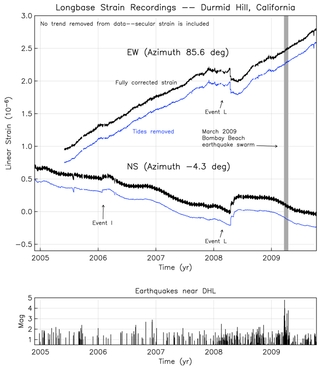
Recent
(Oct’09) strain recordings from the southernmost
terminus of the San Andreas Fault. Events I and L are
episodes of nearby fault creep, which are taken to be
shallow in origin, above the seismogenic portion of the
fault.
Files of raw data are available; these should not be interpreted without detailed knowledge of how the strainmeter operates. These begine on 2 May 2003 (2003:122) when our newest datalogger was installed; for older data contact fwyatt atsign ucsd dot edu.
Files of processed data are also available, in the XML format used for the PBO strainmeters.