The GVS (Glendale-Verdugo Strain) strainmeter is a 558-m fully-anchored instrument oriented N14.71°E, located by the side of the Glendale Freeway on the east slope of Verdugo Canyon. This is about 5 km south of the outcrop of the Sierra Madre thrust zone, in a region identified by Argus et al. (1999) as a zone of concentrated north-south compression. Velocities of nearby geodetic stations from the Crustal Motion Model of the Southern California Earthquake Center suggest both shear and NS compression in the area.
In 1996, SCEC submitted proposals to NSF and to the Keck Foundation to fund the SCIGN project—and as part of this, the proposal to the Keck Foundation included construction and initial operation of at least one long-base strainmeter in the Los Angeles area. Because of our involvement with the GPS side of SCIGN, and time for permitting, construction of this strainmeter only began in 2001. We have had very generous help from both the California Department of Transportation and the City of Glendale in installing the instrument in this unusual location.
Construction took about 18 months, plus a few-month
delay in getting power to the site; this was done on August
18 2002, and the instrument has been working since August 31
2002. We have a number of
photographs
of construction available for viewing.
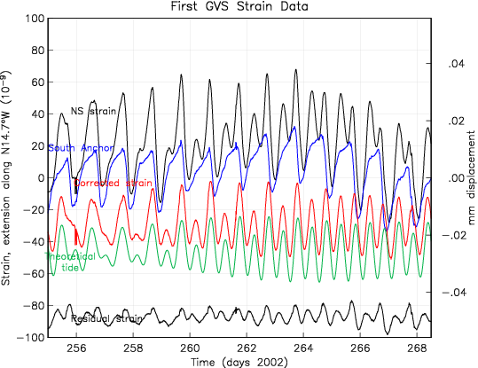
The first plot shows the first days of data from the
instrument: in black, the measured strain between the two
ends. This needs to be corrected using the displacement
measurements from the optical anchors. The one at the south
end shows large displacements, probably because of its
location on shallow fill next to a part of the freeway that
is on an embankment; the north end is on rock, next to a
cutting. The corrected series (red) is much better behaved.
The green series shows the earth tides computed for this
location, including ocean loading but not the local
distortions from the topography. The residual series after
subtracting the tides shows some remaining tidal energy, and
other small fluctuations, probably related to heating of the
vacuum pipe.

The second figure shows the corrected strain from this strainmeter. The end-point anchoring corrections are very important in providing high-quality data. Without these (if we had only the length change) it would not be possible to determine, even roughly, the the longer-period strain changes. It must however be said that the Glendale record, good as it is, is perhaps the most poorly performing of the longbase strainmeters we operate, probably because of one end that is not firmly anchored at depth. The record is usually very clean and very valuable for looking for strain events, but at the times of large rains, which do occur in the foot-hills of Los Angeles, there are responses to the rainfall.
Files of the full (but raw) data from 2002 on are here; these should not be interpreted without detailed knowledge of how the strainmeter operates.
Beginning in June 2005 raw and processed data from this longbase strainmeter have been archived at the PBO Strain/Seismic data center; the data are processed to PBO standards by the Laser Strain Analysis Center in La Jolla. See the Plate Boundary Observatory site for more information.